USNI Logo USNI Logo USNI Logo USNI 150th Anniversary
Donate
  • Cart
  • Join or Log In
  • Search

Main navigation

  • About Us
  • Membership
  • Books & Press
  • USNI News
  • Proceedings
  • Naval History
  • Archives
  • Events
  • Donate
USNI Logo USNI Logo USNI Logo USNI 150th Anniversary
Donate
  • Cart
  • Join or Log In
  • Search

Main navigation (Sticky)

  • About Us
  • Membership
  • Books & Press
  • USNI News
  • Proceedings
  • Naval History
  • Archives
  • Events
  • Donate

Sub Menu

  • Essay Contests
    • About Essay Contests
  • Current Issue
  • Subscribe to Naval History
    • Naval History Digital Subscription
    • Renew Your Subscription
  • Naval History Blog
  • Submisison Guidelines
  • Contact Naval History
    • Media Inquiries
  • All Issues
The wreck of the Titanic, whose tragic sinking in 1912 remains one of the worst sea disasters in public memory, is now viewable with a remarkable degree of clarity.
Public Domain

Sub Menu

  • Essay Contests
    • About Essay Contests
  • Current Issue
  • Subscribe to Naval History
    • Naval History Digital Subscription
    • Renew Your Subscription
  • Naval History Blog
  • Submisison Guidelines
  • Contact Naval History
    • Media Inquiries
  • All Issues

Digital Scan Renders Titanic More Clearly Visible Than Ever

August 2023
Naval History Magazine
Naval History News
View Issue
Comments

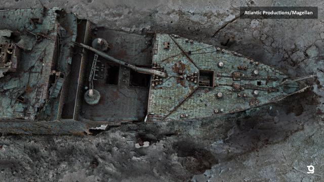
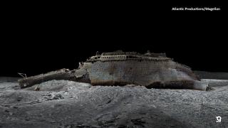
Thanks to modern technology, the world’s most famous shipwreck can be seen in more vivid detail than ever before. The first full-sized digital scan of the wreck of the Titanic—which lies 12,500 feet down in the Atlantic—has been created using deep-sea mapping.

The result of the meticulous effort provides a unique 3D view of the entire ship, enabling her to be seen as if the water has been drained away.

The wreck of the Titanic, whose tragic sinking in 1912 remains one of the worst sea disasters in public memory, is now viewable with a remarkable degree of clarity.

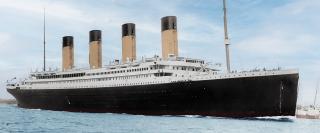
In one of the most tragic events in sea history, the British passenger liner—the largest ship in the world at the time, a ship ostensibly unsinkable—struck an iceberg on her maiden voyage from Southampton, England, to New York City and sank on 15 April 1912 with the staggering loss of more than 1,500 lives.

Now, through the largest underwater 3D-capture project ever undertaken, research scientists have mapped the Titanic in her entirety. From this data, a “digital twin” has been created that shows the wreck with a clarity never before seen. Using technology developed and perfected over five years by deepwater specialist Magellan Ltd., which partnered with Atlantic Productions for the Titanic project, the exact condition of the iconic wreck is revealed, and the entire historic site is mapped, providing an unprecedented level of detail.

Extensive digital scans and a revolutionary 3D-capture renderings of Titanic
Extensive digital scans and a revolutionary 3D-capture technology have rendered the Titanic wreck site in sharper-than-ever detail. Atlantic Productions/Magellan Ltd.

Scans of the wreck were carried out over a six-week expedition in the summer of 2022. The expedition deployed two submersibles—the Romeo and Juliet—which spent many hours at 12,500 feet below the surface, mapping every inch of the wreck in minute detail and mapping the entire three-mile debris field.

As stated in a Magellan Ltd. press release, “The hope is that this will shed new light on exactly what happened to the liner.”

In accordance with tight regulations in place, throughout the project the wreck was not touched or disturbed, and the entire site treated with due respect—including a flower-laying ceremony in memory of the many who lost their lives, as the old ballad goes, “when that great ship went down.”

3D rendering Titanic

Related Articles

Mills/Prom
NH Naval History News

William Prom Named Naval History Author of the Year

August 2023
William J. Prom has been named the 2022 Naval History Author of the Year.
Montevideo Maru
NH Naval History News

Wreck of Montevideo Maru, WWII Japanese Transport, Discovered

August 2023
The wreck of the Montevideo Maru has been located at a depth of more than 13,120 feet off the coast of the Philippines.

Quicklinks

Footer menu

  • About the Naval Institute
  • Books & Press
  • Naval History Magazine
  • USNI News
  • Proceedings
  • Oral Histories
  • Events
  • Naval Institute Foundation
  • Photos & Historical Prints
  • Advertise With Us
  • Naval Institute Archives

Receive the Newsletter

Sign up to get updates about new releases and event invitations.

Sign Up Now
Example NewsletterPrivacy Policy
USNI Logo White
Copyright © 2023 U.S. Naval Institute Privacy PolicyTerms of UseContact UsAdvertise With UsFAQContent LicenseMedia Inquiries
  • Facebook
  • Twitter
  • LinkedIn
  • Instagram
Powered by Unleashed Technologies
×

You've read 1 out of 5 free articles of Naval History this month.

Non-subscribers can read five free Naval History articles per month. Subscribe now and never hit a limit.