
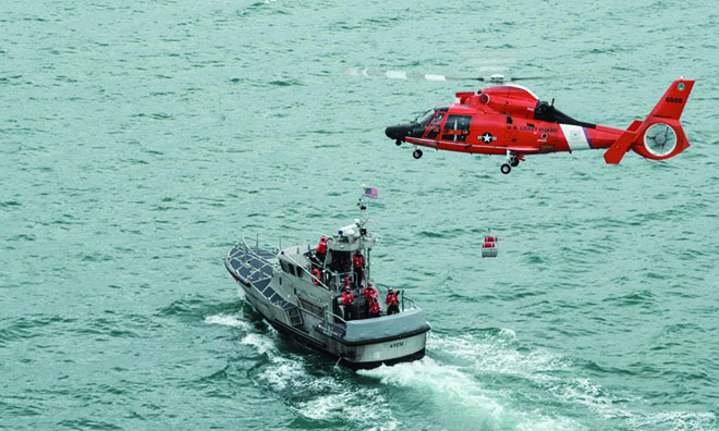
The Rescue 21 radio network allows skilled Coast Guard operators to geolocate the source of Mayday transmissions. Rescue boats and helicopters then are able to proceed to a position rather than having to intiate a large-scale grid search, enhancing victims' chances of survival.
The coastal waters of the Puget Sound are some of the most beautiful in the world, but those same waters also can be deadly for boaters and fishermen. On 18 April 2016, the captain and crew of a 21-foot fishing boat learned that hard fact. Without warning, two rogue waves, one estimated to be 25 feet, hit their vessel, causing it to capsize in a remote area.
A veteran fisherman, the boat operator was able to get out a brief “Mayday” before he and two crew members were forced into the frigid waters. That distress call saved their lives.
The seconds-long transmission was picked up by the Rescue 21 VHF marine radio system operated by U.S. Coast Guard Sector Puget Sound in Seattle. Rescue 21 was able to identify a line of bearing from a Coast Guard Remote Fixed (tower) Facility, and the Coast Guard station at Neah Bay launched a 47-foot rescue boat and diverted a Coast Guard rescue helicopter to coordinates in the vicinity of remote Strawberry Rocks in Makah Bay, a rugged and uninhabited area.
Both the rescue boat and helicopter soon arrived on station. The helicopter vectored in a local fire department rescue boat while Coast Guard petty officers on the motor lifeboat pulled the fishermen from the 52-degree water. The victims had been immersed for more than an hour and required treatment for hypothermia. It was a close call, where minutes meant the difference between life and death.
Coastal Safety Is Complex
The safety of life and property and protection of the maritime environment are shared responsibilities among local, state, and federal agencies; however, the single agency responsible for mission coordination, command, control, and communications is the U.S. Coast Guard. Given the volume of maritime traffic and the range of waterborne activities, the safety of the U.S. maritime public and waterways is a complex job.
What makes this challenge so complex, in part, is size. The littorals of the United States consist of more than 100,000 miles of shoreline. Coastal waters generally are described as extending 50 nautical miles offshore. Included are the five Great Lakes, themselves inland seas. The U.S. territorial sea extends 12 nautical miles, and the exclusive economic zone out to 200 nautical miles.
Each day, these waters are shared by thousands of vessels and their crews involved in a multitude of activities, from recreation and yacht racing to commerce, oil production, commercial fishing, and military operations. Accidents and mechanical failures occur, and thousands of lives are put in peril each year by weather phenomena ranging from fog to hurricanes. Calls for assistance vary from lost pleasure craft to mass casualty incidents. When a major storm such as Hurricane Harvey or Maria hits the U.S. coast, hundreds of calls for assistance are received via VHF marine radio or cell phone passed through hundreds of 911 call centers in cities, towns, and counties along the shorelines. Reliable communications are vital.
Rescue 21
That is where Rescue 21 comes in. The radio network provides coverage throughout U.S. coastal zones and on the inland river system from the Mississippi Delta north to and including the Great Lakes. Analog radio signals are received by towers located at intervals along the coast and then are converted to digital message packets that are processed at regional Coast Guard sectors. There, skilled operators interpret voice transmissions, clarify voice messages, and geolocate the source of the transmissions by developing lines of bearing.
The system is reliable, cost-effective, and has proved to be a lifesaver. In thousands of cases each year, Rescue 21 cuts the time spent searching for victims significantly, thus enhancing their chances of survival.
Rescue 21 was first acquired as an integrated digital radio network to replace the aging National Distress Radio System (NDRS), which was implemented following World War II. NDRS was an analog, VHF-based system that could transmit and receive on only one frequency at a time. It had virtually no direction-finding capability. As a young Coast Guard helicopter pilot in the late 1970s, I flew many hours in search of mariners in distress who made a call for help but were lost because of our inability to locate them.
Finding people in the water, particularly at night, is very difficult. Rescue 21 remedied much of that critical shortcoming. While searches still are required, the majority of distress calls now are resolved quickly and without loss of life. Responding units, including small fast boats and helicopters, generally are able to proceed to a position rather than having to initiate a large-scale, costly grid search. As past Coast Guard Commandant Admiral Paul Zukunft noted, “Rescue 21 is a proven life-saving capability that has increased Coast Guard mission effectiveness by an order of magnitude.”
Evolving the System
As good as the Rescue 21 system is today, it must evolve to continue providing critical mission support and lifesaving services into the future. While hardware obsolescence and system upgrades are provided for as part of General Dynamics Mission Systems’ support contract, new technologies are being developed rapidly by software engineers, the communications industry, the federal government, and others.
Currently, several important issues must be addressed in the near term, including:
• Adequate multiagency Blue Force tracking
• Integration of global positioning and digital selective calling into the Rescue 21 system
• Interagency coordination requirements in the response to incidents in the maritime environment
Critical in the effort to keep Rescue 21 at the forefront of technology is a cooperative research-and-development agreement (CRADA) the Coast Guard has entered into with General Dynamics Mission Systems, the Rescue 21 prime contractor. The purpose of the CRADA is to investigate the operational use of broadband cellular technology, including equipment that may be integrated into the National Public Safety Broadband Communication LTE Network, commonly known as FirstNet.
The initial step in that process is a pilot demonstration project in which General Dynamics will provide mission integration services to Station and Sector Key West. These services include common operating picture applications, satellite radios, handheld mobile devices, and vehicle routers. In addition, General Dynamics will provide shipboard LTE communications equipment for select Coast Guard vessels, boarding teams, command centers, and ground vehicles in Sector Key West, one of the nation’s busiest. LTE network base-station radios will be placed on an existing Coast Guard tower. The pilot is scheduled to begin this winter with over-the-water network coverage analysis and testing.
The Coast Guard then will conduct a six-month study on the suitability, reliability, maintenance requirements, and end-user experience operating the system. The service will evaluate LTE as a mission-critical communications link for the Coast Guard and multiagency public safety and law enforcement operations.
Specifically, the pilot will examine how effectively the LTE network can create a common operating picture for sharing position location information, photos, and reports, as well as transmit high-resolution live video from on-scene incidents to the sector command center. In addition, the project will use the LTE network for transmitting biometric data collected on scene to the appropriate authorities for review and identification. This is particularly useful in smuggling and criminal cases.
The pilot also will examine the utility of the LTE network for transmitting voice and data between cutters and boarding parties in support of tactical boarding operations. For example, Coast Guard personnel on small response boats (SRBs) equipped with ruggedized LTE handheld devices will be able to share voice and data directly with the on-scene cutter, thus allowing the SRB to more quickly and effectively execute boarding operations.
Depending on the outcome of the demonstration project, the next steps could entail the creation of a nationwide, shore-based, water-facing LTE network providing coverage up to many miles from shore. This project has the potential to provide a cost-effective enhancement to Rescue 21 by capitalizing on existing infrastructure while increasing essential capabilities.
100,000 Lives
Rescue 21 is a mature, cost-effective system that is performing exceedingly well. After ten years of operation in the U.S. coastal zone, the number of lives saved as a result of the system is approaching 100,000. While this figure is impressive, statistics often are sterile.
Search-and-rescue professionals know that each save is personal. It means someone who was in peril is alive to return home to his or her loved ones. Someone’s dad, or son, or wife, or daughter gets a second chance at life.
That is the value of Rescue 21 today and into the future.
Vice Admiral Currier retired in 2014 as Vice Commandant of the Coast Guard after a 38-year career. He flew fixed- and rotary-wing aircraft on hundreds of rescue missions. Prior to his retirement, he served as the senior active-duty aviator. On staff, he served as the flag officer overseeing early stages of the Rescue 21 project at Coast Guard Headquarters.