
Maneuvering a DDG Safely and Tactically
By Commander Tom Ogden, U.S. Navy
The commanding officer of a ship is ultimately responsible for the safety, well being, and efficiency of the command.1 Balancing all three while effectively accomplishing the missions that may be assigned is the goal of every captain. To increase the unit’s warfighting effectiveness, a CO can invest in building expertise through training and the thorough use of all available resources, and reducing mistakes while thoughtfully assuming the risk required for mission accomplishment.2 To increase mission success while operating helicopters, a CO must prioritize both, using newly published polar plots to reduce mistakes while developing a keen “seaman’s eye” in every surface warfare officer.
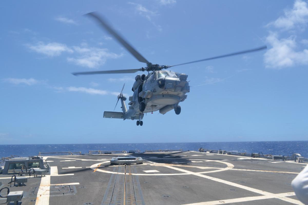
Safer Flight Decks
In the early 2000s, the U.S. Navy began to operate Arleigh Burke–class Flight IIA destroyers on a wide scale. Their flight decks are approximately 15 feet from the water’s edge and designated as low freeboard. As a junior officer, I was trained to operate with helicopters first on an amphibious transport dock and then on a Flight I destroyer. An unwritten rule regarding maneuvering the destroyer while operating helicopters was to prevent waves from impacting the flight-deck nets when the nets were placed in the “down” position to conduct flight operations. Although this seems to be an imperfect rule and somewhat informal, it provided a distinct standard by which junior officers could be trained to ensure the safety of ship equipment (flight-deck nets) as well as the helo on deck. Damaged nets and the physical (and emotional) scars were painful lessons learned by destroyer captains and crews. The rationale for this rule of thumb was that if the sea never impacted the flight-deck nets, then there was minimal chance any seas would impact a helicopter on deck.
However, the USS William P. Lawrence (DDG-110) helo tragedy and fatalities in 2013 exposed the flaws in this unwritten rule, which underestimated the impact of wave run-up on the flight deck and the magnitude of consequence should it happen with a helicopter on deck with rotors turning.3 This incident, and other reports of seawater intrusion on flight decks, led to the creation of polar plots as implemented in NAVAIR 00-80T-122 IC13, “Helicopter Operating Procedures for Air-Capable Ships.” These plots provide a new standard that ships are required to use to safely operate helicopters in various sea states. The implementation of polar plots is a change for the better. They define hazards and identify areas of higher risk while leaving proper authority to the ship CO to determine how to safely maneuver and tactically operate the ship.
Destroyers are the workhorse ships of a carrier strike group. They can conduct tasking across multiple warfare areas, many times simultaneously. Screen stationing and close-formation operations are basic functions for positioning ships to execute tasking. This becomes more complicated when operating in close proximity to an aircraft carrier conducting flight operations while also executing antisubmarine or air-defense operations. Add helo operations and polar plots into the list of requirements and a ship’s freedom to maneuver will become increasingly constrained. Even with an experienced watch team with careful foresight, a CVN escort quickly can find itself out of position if it remains on a set course for flight operations for extended periods.
Understanding a ship’s maneuvering restrictions for flight operations is key to keeping a safe flight deck while also meeting the competing warfighting demands such as screen assignments or antisubmarine maneuvering requirements. Polar plot guidance directs aircrews, helo detachment officers in charge, ship and squadron COs, and destroyer squadron and strike group staffs to continuously update and account for changing conditions and factors that affect a ship’s availability for tasking.4 Ships must also consider the expeditious and safe setting of flight quarters, and timely transitions between flight-deck statuses from Green Deck (ship shall maintain steady course, wind, and ship dynamics) to Amber Deck (ship shall maintain steady course with maximum wind speed of 45 knots) to Red Deck (ship is free to maneuver safely).
Polar Plots in Use
The commander of Naval Sea Systems Command developed the polar plots and the commander of Naval Surface Forces directed their use in December 2014.5 The use of polar plots requires a watch team to assess the sea state as 0–8 feet, 8–10 feet, or 10–12 feet; the relative direction of the seas; and the ship’s speed. Using these inputs, the watch team marks a point on the polar plot chart associated with the estimated wave height. Ship operations in the red regions are not authorized when rotors are engaged and present a significant risk of sea water impacting the H-60 rotor system. Yellow regions indicate hazardous areas where 2 feet of water can wash over the flight deck, risking personnel injury as well as damage to aircraft. Polar plots also offer guidance (as crosshatched areas) where pitch greater than 2 degrees, or roll greater than 8 degrees may occur. Lastly, polar plots offer a note that “operating in the white regions, or in seas below 8 feet, does not eliminate the risk of water impacting the rotor system or washing over the flight deck.”
Although polar plots provide some direction for areas in which a ship shall not operate helicopters, the previously noted disclaimer about the white areas leaves much of the polar-plot areas less defined, requiring additional watch team judgment to operate safely. The number of factors that go into this decision are numerous and can change quickly: Winds, seas, the position of the helo on flight deck, period of swell, speed of ship, degree of rudder used, weight of aircraft, whether takeoff or landing, daytime or nighttime, and the experience of the pilot are a few of the many factors.
It is through hours of training, studying, and observation that a true understanding of these factors is gained, but even then the factors can be very subjective. If you ask two different destroyer COs the wave height on a certain day, you will most likely get two different answers that could vary greatly due to their backgrounds, training, or historical operating areas. With all of these factors at play, the judgment of the CO or the officer of the deck must be relied on to make the correct decision to safely conduct helo operations, just as an experienced “seaman’s eye” informs many other ship operations.
The installation of advanced electronic systems increases situational awareness and makes it easier to gather required information to make informed decisions, but surface warfare leadership should continue to train junior officers to develop—and use—their own senses (eyes, ears, judgment) to build awareness of the situation. Developing a “seaman’s eye” will benefit them not only in maneuvering for helo operations, but for all shipboard maneuvering. Although polar plots provide some limitations, they do not limit tactical maneuvering to maintain station, as long as it in done with due regard to safety of the aircraft, the ship, and navigation.
Safety Recommendations
Polar plots are a step in the right direction to increase a ship’s ability to conduct safe flight-deck operations, but placing too many restrictions on a ship can limit the initiative of a commander, undermine mission accomplishment, and runs counter to the tenets of command at sea. To safely operate helicopters from low freeboard ships, the following recommendations should be considered:
• Continue to put the responsibility for safety and mission accomplishment on the CO of the ship, while ensuring risk factors are known as much as possible (polar plots do this to an extent).
• Ship COs and OODs should experiment with speeds, turn rates, and wave run-up while there is no helicopter on deck to gain firsthand understanding of the impacts of sea states, turn rates, and wave run-up in differing conditions. The USS Chung-Hoon (DDG-93) has completed run-up estimates and has seen how turn rate, winds and swell period, direction, and timing increase the chance for sea spray or sea water to impact the flight deck nets or the flight deck.
• Train all junior officers to develop a seaman’s eye using both technological advances and our natural human senses. Training these senses is imperative forthe learned intuition that is ultimately required for success and safety in a seagoing operating environment.
• Train all destroyer squadron staffs, screen commanders, and other afloat staffs in the use of polar plots and possible impacts on maneuvering.
Destroyer-based flight operations require aviators to operate the helicopter and surface warfare officers to operate the ship in concert. These two communities must work together while understanding that there are cultural differences between the surface warfare and aviation communities. Surface warfare officer (SWO) training and mission execution from the Cold War through the early 21st century has largely been biased toward operational success and mission accomplishment while absorbing the right level of risk at the unit level.
Additionally, there are not many SWOs who have lost friends to mishaps, whereas the deadly impacts of a safety-related issue in an aircraft leads to aviators being more personally and professionally invested in the safety discussion. Early on in their careers, aviators are inculcated into a culture of safety, such that a bias toward safety exists. Although aviators are also trained to be mission-oriented, this safety bias creates clear lines—the majority being safety related—that aviators will not cross.
In 1965 the U.S. Navy established the Aviation Safety School in Monterey, California, but has assigned primary duty safety officers to aviation squadrons since the 1950s.6 The surface community is just now assigning primary duty safety officers. A welcome step forward for the surface warfare community, the first primary duty safety officers to be assigned to destroyers began arriving to their ships in 2015. Previously, first-tour department heads filled the safety officer role as a collateral duty. The naval aviation community saw the number of mishaps drop drastically in the 1950s and 1960s after focusing on safety while still flying successful missions and being widely known as some of the best aviators in the world.
The surface warfare community will benefit from the added focus of a primary-duty safety officer. This is helpful, especially considering the increased focus on helicopter safety that the new polar plots bring. Even with these advances, the most beneficial factor in safe helo/DDG operations is keeping the authority and responsibility of command where it should lie—with the CO.
1. Navy Regulations 1990, Chapter 8 The Commanding Officer, 0802.
2. Gary Klein, Streetlights and Shadows: Searching for the Keys to Adaptive Decision Making (Cambridge, MA: MIT Press, 2009).
3. www.cpf.navy.mil/foia/reading-room/2014/05/hsc-6.pdf.
4. NAVAIR 00-80T-122 IC13, 7–2.
5. COMNAVSURFOR Message 102344ZDEC2014, NAVSEA DDG51 Class Advisory 04-2014, Helicopter Launch, Recovery, and Movement on Deck Operator Guidance.
6. www.public.navy.mil/navsafecen/Pages/aviation/SAS/ASO-Cmd-history.aspx.
Commander Ogden is the commanding officer of the USS Chung-Hoon. He is a 1998 graduate of the U.S. Naval Academy and holds an MA in security studies from Georgetown University.
Search and Rescue in the Arctic
By Commander Douglas T. Wahl (Retired) and Commander Timothy P. McGeehan, U.S. Navy
An SOS has been sent. A small ecotourism cruise ship operating in the Arctic’s marginal ice zone north of Barrow, Alaska, is in trouble. While operating in poor visibility due to fog, she struck sea ice, which opened a hole in her side. A watertight door has failed and she is flooding uncontrollably. Passengers frantically don survival suits and board lifeboats as the ship sinks into the freezing waters.
The U.S. Coast Guard command center monitoring the ship’s progress receives and acknowledges the SOS. The service assumes command of the search-and-rescue (SAR) operation and dispatches a C-130 to act as the airborne command post, survey the scene, and relay full-motion video back to the command center. The SAR commander vectors in a nearby cutter and launches two shore-based helicopters to airlift passengers requiring urgent medical attention.
A U.S. Navy destroyer is steaming in the vicinity of Barrow. At the Coast Guard’s request, she proceeds to the scene, where her helicopters assist with the recovery of survivors. Time is the enemy; Navy weather forecasters predict the development of a polar low, an intense storm referred to as an “Arctic hurricane.”1
The storm hits as the sun rises the next day, but by then all 150 survivors have been recovered and transported ashore to a nearby base where they are triaged, treated for cold-related injuries, and sheltered to wait out the storm.
Variations of this scenario have frequently been used to highlight the scope and challenges of Arctic operations. In fact, it isn’t just a scenario: The MS Explorer, an ecotourism cruise ship, sank under these circumstances. Although she sank in Antarctic rather than Arctic waters, the hazards are similar.2 The fictional aspect of this story was the response, which would not be possible with today’s Arctic capabilities and infrastructure.
Sea ice is decreasing at a rate faster than global climate models predict.3 In particular, the thick multiyear ice that was frequently encountered is now rare. Increased activity is likely to occur in conjunction with efforts to harvest resources—namely oil, gas, minerals, and fish. As much as 10 percent of the world’s known conventional petroleum resources are located in the Arctic.4 The Bering Sea supports a multibillion-dollar fishing industry, and several species have extended their range northward into the Arctic Ocean.5 However, resources are only part of the allure.
In September 2013 the ice-strengthened bulk carrier Nordic Orion made history as the first commercial vessel to transit the Northwest Passage as a trade route, sailing from Vancouver to Finland loaded with coal.6 As Arctic sea ice recedes, the Northwest Passage and the Northern Sea Route may become consistently passable to shipping. There is potential for significant savings of time, distance, and money. The Northern Sea Route cuts the distance between Rotterdam and Yokohama (via the Suez Canal) by 4,700 nautical miles, while the Northwest Passage reduces the distance from Rotterdam to Seattle (via the Panama Canal) by 2,000 nm, and the route between Europe and Asia (around Cape Horn) by 12,000 nm.7 However, the widespread adoption of these routes may prove limited somewhat by size of the vessel, depth of the water, ports of origin and destination, and susceptibility of the route to environmentally imposed delays.
Potential Shortfalls
Communications. The cruise ship’s SOS that triggered the rescue operation in the opening scenario would have gone unanswered with today’s communications infrastructure. The Global Maritime Distress Safety System does not work above 75 degrees north. Long-range communications are difficult in the Arctic due to the great distances between transmitters and receivers, ionosphere interactions, and other environmental factors. Most satellite systems, including geostationary military communications systems and beyond line-of-sight communications used for ship-to-shore connectivity, are not designed for coverage above 65–70 degrees north.
Reliable communications to support command-and-control and maritime-domain awareness are fundamental to future Arctic operations. Netted Iridium satellite communication is the only reliable high-latitude option. While it allows voice, texting, and data, service costs can exceed one dollar per minute. While military users have an emerging alternative in the Mobile User Objective System, which has shown promise extending coverage well into the Arctic, there is no commercial counterpart.8
Navigation. It is not safe for surface ships to operate in the Arctic without navigational charts and aids to navigation. GPS is fully operational at the poles and meets required navigation standards, but less than 6 percent of the Arctic is charted to modern standards, and current digital nautical charts do not extend beyond 84 degrees north.
The track record for polar (Arctic and Antarctic) navigation is poor. In 1996 an ice-strengthened cruise ship went aground near Gjoa Haven, Nunavut. Between 2000 and 2008, polar cruise ships established an appalling safety record: 5 ships sunk, 16 groundings, 42 environmental or pollution violations, and 28 ships disabled by collision, fire, or propulsion loss.9 In 2010 another cruise ship hit an underwater ledge near Kugluktuk, Nunavut, highlighting the potential of a major SAR event.10
Capable platforms. The Navy destroyer in the scenario is not realistic because there are no surface combatants that are ice-hardened or certified to operate in the Arctic, nor are there existing requirements to have any. This would require extra heating and insulation, a steam-supply system for removing ice from deck equipment, and heated fuel, lubricant, and waste heaters. Ice-hardening an existing destroyer would cost between $20 and 30 million. Such a vessel could operate in 60 percent ice-covered seas, with up to 1 foot of sheet ice without the support of an icebreaker, but would be noisier and less fuel-efficient.11
The Navy ceded icebreaking responsibilities to the Coast Guard in 1965 with the expectation that it would provide mobilization capability for the military in high-latitude regions when required. The Coast Guard currently has only two operational Arctic icebreakers in service.
Logistics and training. The ability to physically execute and sustain Arctic operations is suspect. Logistics capabilities such as fuel, consumables (food and repair parts), and limited maintenance facilities are required to support operations by surface combatants. Additionally, cold weather gear, training, and certification for Arctic operations will have to be developed.
Meteorology and oceanography. The weather forecast providing urgency to the SAR operation would probably not have happened either. Weather and ice forecasting in the Arctic is exceptionally difficult due to limited sensing capability and forecasting expertise. Much remains unknown about Arctic weather, such as understanding polar lows, which form and dissipate so rapidly that they present major challenges to operational weather models.12
Infrastructure. The final component of the scenario was perhaps the most fictitious. Where in the Arctic would we operate from? The infrastructure required to conduct sustained naval surface and air operations in the Arctic is currently nonexistent. The closest warm-water naval base is Everett, Washington, 2,900 nm from the Alaska North Slope.
Multiple studies suggest the need for a permanent hangar on the North Slope to enable Arctic SAR operations. The State of Alaska is constructing a hangar in Barrow for lease to the Coast Guard during exercises. However, Barrow is limited to resupply from sea or air because a ground resupply route does not exist. The only existing infrastructure is in Prudhoe Bay, and its facilities are only capable of housing two Coast Guard helicopters.
Arctic infrastructure includes Dutch Harbor, whose location in the Aleutians puts it in the shipping lanes between North America, East Asia, and the Bering Sea. However, year-round harsh weather prevents Dutch Harbor from being a viable SAR location. Adak, lying 390 nm west of Dutch Harbor, had an installation, but it was shut down in 2000 under the 1995 Base Realignment and Closure Act. Today’s lack of infrastructure is not easy to remedy. Construction in the Arctic is seasonal and skilled labor is in short supply, driving costs from three to five times higher than comparable infrastructure in lower latitudes.
SAR missions. The SAR example highlights several national shortcomings in the Arctic, and the scenario may play out as activity gradually increases. Larger cruise ships, such as the 1,070-passenger Crystal Serenity, which will attempt to sail from Anchorage to New York via the Northwest Passage in August 2016, raise concern that the sheer number of passengers exceeds the rescue capacity of any nation.13 Indeed, even if the passengers could be rescued, where would they go? Without sufficient shelter, they would only survive the rescue to die of exposure ashore.
While SAR is a Coast Guard responsibility, the Navy may be called to support. However, the fiscal situation dictates that the Navy weigh requirements to support actual warfighting demands today against investments to address hypothetical SAR events in the future. Shortfalls described here, particularly those requiring matériel solutions, may not be remedied in the near future—nor should they be. If resource constraints require our nation to accept a gap in aircraft carrier presence in the Persian Gulf despite everything going on there, surely it is reasonable for our Arctic investments to be made in step with the pace of environmental change and as actual activity increases in the region.
Furthermore, part of the SAR solution lies not with the Navy or Coast Guard, but with industry. Much has been made of the Crystal Serenity’s planned voyage, but little has been made of the escort ship that will travel with her. The British Antarctic Survey’s research vessel Ernest Shackleton has been chartered to provide on-site rescue and assistance.14 Whether in the form of increased insurance premiums or requiring ships to travel in company for mutual assistance, industry bears significant responsibility for managing the risks associated with operating in increasingly remote locations.
The challenges posed by Arctic SAR operations were illustrated in 2013 when a Canadian Coast Guard helicopter crashed into the icy waters of the Northwest Passage. The three men on board, including the icebreaker’s commanding officer, drowned “due to cold incapacitation” despite the immersion suits they were wearing in the hour it took the icebreaker Amundsen to reach them.15 This raises a fundamental question: When it comes to Arctic SAR, given the extremely short survival times imposed by the harsh environment, would improved communications, navigation, forecasting, logistics, and infrastructure really matter?
1. Alan Condron and Ian Renfrew, “The impact of polar mesoscale storms on northeast Atlantic Ocean circulation,” Nature Geoscience, 2013, www.nature.com/ngeo/journal/v6/n1/full/ngeo1661.html.
2. Binyah Kesselly, Report of Investigation in the Matter of Sinking of Passenger Vessel EXPLORER on 23 November 2007 in the Bransfield Strait near the South Shetland Islands (Republic of Liberia, Bureau of Maritime Affairs), March 2009, http://mararchief.tudelft.nl/catalogue/entries/9116.
3. Julienne Stroeve, Marika Holland, Walt Meier, Ted Scambos, and Mark Serreze, “Arctic sea ice decline: Faster than forecast,” Geophysical Research Letters, vol. 34, no. 9, 16 May 2007, http://onlinelibrary.wiley.com/doi/10.1029/2007GL029703/abstract.
4. Kenneth Bird, Rohnald Charpentier, Donald Gautier, et. al., “Circum-Arctic Resource Appraisal: Estimates of Undiscovered Oil and Gas North of the Arctic Circle,” U.S. Geological Survey, Fact Sheet 2008-3049, 2008, http://pubs.usgs.gov/fs/2008/3049.
5. Gary Hufford, National Weather Service Alaska Region Sea Ice Program, 3rd Symposium on the Impacts of an Ice-Diminishing Arctic on Naval and Maritime Operations, 2009, www.star.nesdis.noaa.gov/star/documents/2009Ice/Day2/Hufford_day2.pdf, 1–39. Libby Logerwell, Cruise Report for the 2008 Beaufort Sea Survey, F/V Ocean Explorer, 27 July–30 August 2008, NOAA: U.S. Department of Commerce National Marine Fisheries Service, Alaska Fisheries Science Center/ U.S. Department of the Interior Minerals Management Service, Alaska OCS Region, www.afsc.noaa.gov/REFM/Stocks/fit/PDFS/Beaufort_sea_cruise_report.pdf.
6. Michael Byers, “Canada’s Arctic Nightmare Just Came True: The Northwest Passage is Commercial,” The Globe and Mail, 20 September 2013, www.theglobeandmail.com/globe-debate/canadas-arctic-nightmare-just-came-true-the-northwest-passage-is-commercial/article14432440.
7. Scott Borgerson, “Arctic Meltdown: The Economic and Security Implications of Global Warming,” Foreign Affairs, vol. 87, no. 2 (March/April 2008), https://www.foreignaffairs.com/articles/arctic-antarctic/2008-03-02/arctic-meltdown, 63–77. John Falkingham, Sea Ice in the Canadian Arctic in the 21st Century: Canadian Ice Service Report, 2000, 5.
8. Sam LaGrone, “Lockheed, Coast Guard Tackling Problem of Arctic Communication,” USNI News, 21 August 2014, http://news.usni.org/2014/08/21/lockheed-coast-guard-tackling-problem-arctic-communication.
9. John Snyder, “Tourism: A Growing Presence in an Ice Diminishing Arctic,” 3rd Symposium on the Impacts of an Ice-Diminishing Arctic on Naval and Maritime Operations, 2009, www.star.nesdis.noaa.gov/star/documents/2009Ice/Day2/Snyder_day2.pdf, 1–20.
10. Michael Byers, “Canada’s Arctic Nightmare Just Came True: The Northwest Passage is Commercial.”
11. Michael Bowes, Impact of Climate Change on Naval Operations in the Arctic, CNA Report, April 2009, https://www.cna.org/CNA_files/PDF/D0020034.A3.pdf, 30.
12. Alan Condron and Ian Renfrew, “The impact of polar mesoscale storms on northeast Atlantic Ocean circulation.” Trond Iverson, “Polar lows: A challenge for predicting extreme polar weather,” WWRP/THORPEX/ECMWF Workshop on Polar Prediction, June 2013, www.ecmwf.int/sites/default/files/elibrary/2013/13925-polar-lows-challenge-predicting-extreme-polar-weather.pdf.
13. Rob Lovitt, “Crystal Cruises Sets its Sights on the Northwest Passage,” NBC News, 8 September 2014, www.nbcnews.com/business/travel/crystal-cruises-sets-its-sights-northwest-passage-n192106. George Newton, “A Concept from a Concern: The Arctic Emergency Liaison Office,” 3rd Symposium on the Impacts of an Ice-Diminishing Arctic on Naval and Maritime Operations, 2009, www.star.nesdis.noaa.gov/star/documents/2009Ice/Day2/Newton_day2.pdf, 1–21.
14. Chamber of Shipping of British Columbia, “Crystal Serenity NW Passage escort ship announced,” 12 November 2015, www.cosbc.ca/index.php?option=com_k2&view=item&id=2008:crystal-serenity-nw-passage-escort-ship-announced&Itemid=292.
15. Michael Byers, “Canada’s Arctic Nightmare Just Came True: The Northwest Passage is Commercial.” “Coast Guard helicopter crashed in Arctic due to lack of visual cues and pilot distraction,” CBC News, 7 December 2015, www.cbc.ca/news/canada/north/arctic-coast-guard-helicopter-tsb-1.3354234.
Commander Wahl, a former naval oceanographer, is a systems engineer at Science Applications International Corporation.
Lessons in Submarine Innovation
By Captain John D. Zimmerman, U.S. Navy
In late 2013, the submarine force decided to modernize the 1990s-era combat systems on Ohio-class submarines. As the Submarine Combat and Weapon Control Systems (PMS-425) Program Manager, I realized that it would take until 2022 to modernize all ballistic-missile submarine (SSBN) combat systems due to the process we use for developing software and hardware. I asked my team, “How might we bring as much submarine combat-system capability to the entire SSBN fleet, for as little money as possible, in one year’s time?” With no program dollars set aside for this initiative, any resources required would have to come from other organizations or from savings within our program.
The submarine force has an excellent tradition of bringing modern commercial hardware and combat-system software to the fleet. The Rapid COTS (commercial off-the-shelf) Insertion process is the means by which new commercial hardware and combat system software are developed for nuclear-powered fast-attack submarines (SSNs) and cruise-missile submarines (SSGNs). It relies on the Technology Insertion (TI) process, which provides new computer hardware, and the Advanced Processing Build (APB) process, which develops new combat system software. These processes run on a two-year development cycle, offset by a year so that engineers can develop software on hardware that is in the final stages of production and vice versa.
The PMS-425 Program Office vision is “any submarine combat system capability on any hardware at a reasonable cost.” It endeavors to improve on the standard of excellence established by the TI/APB process. The key to doing so was developing software that could run on many hardware baselines, not just the most current computer hardware. If we achieved this goal, then as soon as new software was developed, it could be installed through fast and inexpensive software upgrades instead of the slower and significantly more expensive hardware modernizations. It was this vision, plus the challenge from Admiral Jonathan Greenert, the Chief of Naval Operations at the time, to “get faster,” that inspired this initiative.
Finding Value
The submarine combat system is comprised of two subsystems: the tactical control system (TCS) and the weapon control system (WCS). The TCS generates an operational picture using ship sensors (sonar, radar, etc.), while operators use the WCS to place ordnance (either torpedoes or tactical missiles) on target. Because the WCS changes require extensive testing, we decided this effort would focus only on upgrading the TCS.
To keep costs down and reduce development and installation time lines, our team concentrated on how to reuse current TCS software and the SSBN legacy combat system hardware. Over the years, more than $100 million has been spent developing TCS capabilities. Besides the current TCS software, our team identified a new mission-planning application being developed by the Office of Naval Research as well as a satellite-vulnerability tool, developed by the Johns Hopkins University Applied Physics Lab, to be added to the TCS upgrade.
The team planned to use as much of the legacy combat-system hardware as possible. Initially, laptops were considered since they were inexpensive and easy to install. However, fleet feedback was not positive. The laptops had limited processing power, and they crowded the limited space in the SSBN control room. Based on this feedback, the team decided to integrate one new computer server with the legacy SSBN combat system to run the latest TCS software on the installed SSBN workstations. This provided a tremendous increase in processing power while eliminating the need for new combat-system workstations. What remained was to determine if the new server could be integrated into the legacy combat system and provide enough computing power for all the new software applications.
Having little money and little time, the team used simple prototypes to determine what might be achieved. Within one month of starting the project, the interface was developed to prove the concept was viable. Based on this progress, the team held a Concept of Operations Experiment (COOPEX) for fleet representatives at the Naval Undersea Warfare Center in Newport, Rhode Island. The COOPEX demonstrated the software being run by the new server integrated into the SSBN combat system. In this early configuration, not all capabilities could be supported, and of greater concern, there were still many technical issues that needed to be resolved. In fact, at the time of demonstration, the latency of the integrated system was so bad that there was a five- to ten-second delay between the time an operator initiated an action and the action actually occurring. Regardless, fleet participants made it clear that if the latency issue could be resolved, the initiative would be a tremendous improvement over current SSBN TCS capabilities.
Taking Risks Together
With fleet buy-in established, but still numerous technical, operational, and schedule hurdles to overcome, the PMS-425 team quickly implemented the contract modifications required to purchase the necessary hardware and to begin integrating the new server into the SSBN combat system. PMS-425 purchased the hardware without any assurance that the system would ever be installed. Our team accepted this risk based on initial fleet support for the initiative and the engineering assessment that the remaining technical issues could be solved.
While there was significant support, a number of fleet representatives were concerned by the risks required to bring this concept to fruition. There was still much to be done. Submarine Development Squadron 12 would have to develop employment guidance, the Submarine Learning Center would need to develop new training curricula, and the Trident Training Facilities would need to schedule the required training in facilities that were already fully booked. Most important, the submarine squadrons and submarine crews would need to accept the risk of committing to, and training on, a system that had not yet been fully certified or tested at sea, to ensure their crews were ready to employ it once final testing and certifications were complete.
Our team solved many technical and performance problems. Within 12 months of concept initiation, the system was successfully installed in three training facilities in Bangor, Washington, and Kings Bay, Georgia. Due to fleet willingness to take risks, and a lot of hard work, the required employment guidance and training products were also ready.
The installation of the TCS upgrade in the training facilities offered a number of opportunities: to get the system into the hands of the fleet operators, to demonstrate the system could be quickly installed, and also to prove the reliability of the system through many hours of use. With these opportunities came more risks.
While the system had been tested extensively, there were still technical issues that needed to be fixed. The system was deemed “good enough” for installation into the trainers. Our goal was to deliver these capabilities to the fleet as soon as possible, without providing a product with so many issues that it could result in a loss of support.
Unfortunately, setbacks occurred. The initial installation did affect the performance of the legacy combat system. With the TCS upgrade system in operation, operators had to enter a solution twice before the system fully accepted it. While this may seem minor, and the SSBN crews quickly adjusted to this annoyance, the real issue was that the TCS upgrade was having an impact on the legacy combat system at all. Due to another technical issue, at certain times all the contacts in the system would “clump” to the same default solution. For a system whose primary purpose is to paint an accurate operational picture, this was a very significant problem.
Small Risks, Big Rewards
Fortunately, the submarine crews continued to train with the system while technical issues were being resolved. Commander Ken Curtin, the captain of the USS Wyoming (SSBN-742) (Gold), was an excellent example of this willingness to accept risk. After seeing the system in operation, he eliminated all planned legacy combat-system training and fully committed to training his officers and crew on the TCS upgrade system.
His instincts turned out to be correct. Our team eventually resolved both technical issues, completed all testing and certifications, and on 24 July 2015 the TCS upgrade was successfully installed in the Wyoming, making it the first ballistic-missile submarine in the U.S. Navy to receive the TCS upgrade.
The fact that many organizations were willing to take small risks enabled this success, and achieved very significant rewards for the fleet. In less than two years, this effort progressed from concept to reality. Each new server brings with it more than 50 times the computer-processing power than the legacy SSBN combat system, the latest tactical control-system capabilities, and the most modern mission-planning capabilities available in the submarine force today.
Just one operator can now perform the functions previously performed by three on the legacy SSBN combat system. Previously, officers and fire controlmen on SSBNs had a significant training burden when they transferred to a SSN or SSGN. This upgrade put them on par or ahead of all the SSNs and SSGNs in the submarine force, providing operators that were better trained and could be more easily transferred to different submarines. Due to the extremely small size and ease of installation and testing, the upgrade has already been installed in three fleet trainers and 11 SSBNs. This effort represents the fastest, least expensive, and most significant improvement in tactical control-system capabilities in the history of the U.S. Navy submarine force.
Captain Zimmerman served as the major program manager for the Submarine Combat and Weapon Control Systems program (PMS 425) from 2012 to 2015. From 2006 to 2008 he commanded the USS Jefferson City (SSN-759). He was recently recognized as an Honorable Mention for the Secretary of the Navy’s Innovation Leadership award.