
Digital F-14s Get the Picture—Fast
By Commander Mark L. Bathrick, U.S. Navy
Two aircraft launch from a forward-deployed carrier toward a potential target in hostile territory. One is equipped with the Tactical Airborne Reconnaissance Pod System (TARPS) fitted with the prototype digital imagery (DI) camera, air-to-air weapons, and two laser-guided bombs. The other carries the Low Altitude Navigation and Targeting Infrared for Night (LANTIRN) Targeting System (LTS), air-to-air missiles, and two laser-guided bombs.
Their target is mobile—a ballistic missile launcher—but it could just as well be fixed. Intelligence has given them the launcher's most likely location. The first aircraft uses its TARPS (DI) to image the target, and transmits it back to the warfare commander for positive target identification. Confirmation comes less than ten minutes later, whereupon the wingman drops a laser-guided bomb and obtains bomb hit assessment (BHA) on tape using the aircraft's forward looking infrared (FLIR).
Near real-time bomb damage assessment is provided by a second set of TARPS (DI) images taken following the strike. These images also are relayed to two Air Force strike fighters headed for secondary targets in the area. Both the pre- and post-strike images are forwarded to the National Command Authorities where they are available for analysis or release to the media before the aircraft recover on board the carrier.
Thousands of miles away, a commander conducting a non-combatant evacuation operation is searching for intelligence on hostile forces in the area. He sends a section of similarly equipped aircraft over the evacuation site where the TARPS (DI) aircraft transmits images back to the command ship. Meanwhile, the LTS aircraft scans the area for signs of thermal activity—trucks or tanks—which will be reported via voice, supplementing the information provided by the transmitted images. Following this, they maintain a defensive air-to-air and air-to-ground patrol over the objective, providing the warfare commander with regular image updates of the evacuation's progress.
This is not a vision of the future; the capability exists today. Carrier Air Wing Three on board the USS Theodore Roosevelt (CVN-71) demonstrated it during 1996-1997 workups and Mediterranean-Persian Gulf deployment.
The normal F-14 TARPS configuration consists of three electro-optical/infrared (EO/IR) sensors in a pod hung from the aircraft. Each of these sensors provides images on wet film, which must be processed post-flight. The TARPS (DI) capability replaces the KS-87 serial frame camera with a digital camera, two viewfinders, and an image processor that permits transmission of images to a ground station while the aircraft is in flight.
This near real-time imagery capability has expanded the utility of the F-14 in the reconnaissance role in missions where time is critical. With TARPS (DI) installed, both pilot and radar intercept officer (RIO) can view the image through either the 25-mm viewfinder or through the digital camera lens. The slightly wider field of view of the viewfinders over the actual camera field of view aids the aircrew in localizing and aligning the targets before the RIO actually snaps the picture, storing it on the solid-state storage device. At that point, he has several options:
- Transmit the image immediately.
- Store the image for review and later transmission.
- Await download of all images upon recovery aboard the carrier.
If the RIO decides to transmit the image, he can send it via the aircraft's secure ultrahigh frequency radio to the digital camera receiving station (DCRS) located in a van ashore or on board ship. Normal transmission times range from 30 to 180 seconds at ranges up to 175 nautical miles.
Following a series of ground and flight tests at Naval Air Station Oceana, Virginia, Carrier Air Wing Three brought the TARPS (DI) system to NAS Fallon, Nevada, as part of air wing strike detachment. In one exercise, TARPS (DI) found and imaged a simulated mobile
SCUD-type missile launcher. While searching the assigned area, the TARPS (DI) crew imaged several possible contacts. These were transmitted to the Naval Strike and Air Warfare Center (NSAWC) simulated Combined Air Operations Center (CAOC). Possible targets were evaluated and confirmation provided while the aircraft were still overhead each objective. Upon receiving clearance to engage, the TARPS (DI) and escort aircraft simulated target destruction and relayed the image of the destroyed mobile launcher to the operations center for analysis and dissemination; the whole process took less than ten minutes.
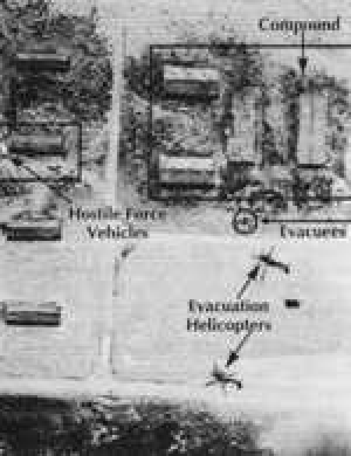
In another exercise, the system provided updates and assisted in the coordination of a simulated noncombatant evacuation. Positioned directly over the objective, the aircraft provided the commander with images of rescue helicopters landing in the compound, evacuees filing into helicopters, and simulated enemy vehicles around the compound. This information was used to assess the timing and progress of the operation as well as redirect forces toward or away from enemy positions.
While deployed to the Mediterranean in late 1996 and early 1997, Air Wing Three employed the system in support of Operation Determined Guard over Bosnia-Herzegovina. Following the imaging of the objective—a hydroelectric power plant—the digital image was downloaded and forwarded from the Theodore Roosevelt to the U.S. National Intelligence Cell (USNIC) in Vicenza, Italy. From there, it was transmitted to two airborne U.S. Air Force F-15Es.
In February 1997, an Air Wing Three F-14 imaged the French aircraft carrier Clemenceau, which was participating in a combined exercise with the Theodore Roosevelt battle group, and transmitted the image. Taken at 1600 local, it was reviewed and transmitted back to the Theodore Roosevelt's DCRS. On board the carrier, the image was enhanced, sized, labeled, and transferred to the carrier intelligence center homepage on a classified internet. Less than 30 minutes after the image was taken, a picture of the Clemenceau was available in Washington, D.C., at the Naval Air Systems Command and the Navy Command Center.
Operation Southern Watch provided another opportunity to demonstrate the system's capabilities. On 6 April, a mission photographed a target in southern Iraq and transmitted it to the receiving station on board the carrier. At 1320 local, air crews completing their preflight briefing in preparation for an upcoming strike familiarization flight were able to conduct up-to-the-minute target study using the image transmitted from the still-airborne F-14.
On another mission, planners chose a railroad station in Iraq to photograph and transmit to the Joint Task Force-Southwest Asia headquarters in Saudi Arabia. The aircrew successfully acquired the target and transmitted it to the carrier, where it was reviewed, and then relayed. The total time from photograph to receipt by the headquarters was 32 minutes.
The system's digital nature improves image analysis and interpretation, which often require enhancement. Wet film enhancement requires time and talent to determine the adjustments necessary and then reprocess the pictures to achieve the desired affect. Digital images, however, can be enhanced using the latest computer techniques with the results available for immediate interpretation on the computer screen.
The initial deployment merely scratched the surface of the potential this capability brings to warfare and theater commanders. The relative simplicity and low cost of the DCRS means it can be packaged and deployed with amphibious and maritime interdiction forces, and ground units—permitting the TARPS (DI) aircraft to work directly with the unit requesting the reconnaissance services, and providing individual units with their own near real-time image gathering capability. Unlike unmanned aerial vehicles, a manned aircraft can be controlled by any unit with a radio, and the crew can review images prior to transmitting them to the requesting unit. In addition, manned aircraft provide increased flexibility for the tasking unit.
The intrinsic endurance of the F-14 TARPS (DI) platform means that commanders can rely on this capability being available over a suitable period of time. The ability of the TARPS (DI) Tomcat to carry both air-to-air and air-to-ground ordnance while still performing this mission ensures not only its own self-protection, but also provides surface and ground commanders with additional offensive options.
The system complements the aircraft's forward air controller (airborne) (FAC[A]) mission. Able to snap and review images of potential targets, FAC(A) crews will be better able to analyze and describe targets to close air support (CAS) aircraft from a sanctuary of some distance from the target. Future aircraft improvements could provide images of these targets directly into CAS aircraft, similar to the effort conducted during this deployment, transmitting images into the cockpit of F-15E aircraft via the CAOC.
The rapid and relatively inexpensive development, testing, and integration of TARPS (DI) into the Navy's carrier air wings represents a success story for the Department of Defense. Programs like this, which increase operational capabilities by using commercial systems, represent a real way to do more with less. The use of operational units to assist in system development and testing takes advantage of talent and training already resident—and the system's successes should encourage the digitization of the other TARPS wet-film sensors. Fully digitized, TARPS would provide a powerful tool to the joint forces commander in establishing dominant battlefield awareness while providing a model for follow-on tactical reconnaissance systems.
Commander Bathrick, a naval aviator, commands Fighter Squadron (VF)-32. He has served with the Chief of Naval Operations Staff and the Joint Staff.
We Got More Breaks Than Halsey…
By Lieutenant Commander Ray Robichaud, U.S. Navy
The barometer started falling and the wind picked up from the southeast, but it was December in the Western Pacific and the telltale signs received little attention for some time within the task force. As the wind increased and the barometer continued to fall, however, it became obvious that a tropical storm was forming.
Plans to refuel the escorts the next morning came to naught as the winds increased throughout the night and the sea state rose. The escorts were going into the storm riding high in the water. The weather center at Pearl Harbor was uncertain as to the location and intensity of the storm because of sparse data. Several commanding officers suspected what should have been obvious: a major typhoon was developing.
A barometer falling several hundredths of an inch per hour is an undeniable indicator that a major storm is approaching. Some commanding officers made preparations for the upcoming tempest, filling their fuel tanks with sea water to increase stability and securing their ships. On the carriers, aircraft were secured with storm tie-downs.
The task force commander, however, maintained course because of his mission. The barometer continued to fall and winds veered to the south and increased to more than 100 knots with gusts to 200 knots. Seas built to mountainous heights as ships began to fight to stay afloat.
It was 1944. The lack of prediction capability, both on-scene and at the Pearl Harbor Weather Center, and Admiral William F. Halsey's decision to press on, resulted in the losses of three destroyers, 778 men, and 100 aircraft. Four aircraft carriers suffered major damage as aircraft broke loose from their tie-downs and ruptured fuel tanks filled with aviation gasoline started fires on the flight decks and in hangar bays. On the San Jacinto (CVL-30), all of the stowed aircraft in the hangar bay broke loose from their tie downs.
In November 1996, the USS Independence (CV-62) battle group was threatened by a remarkably similar typhoon while participating in Annual Exercise (AnnualEx) with more than a dozen U.S. and Japanese ships. In this case, however, the exercise was terminated early as the group diverted to Yokosuka, Japan, successfully avoiding one of the most powerful super-typhoons in recent history. As it was, the ships experienced gale-force winds and 16- to 18-foot seas, 850 miles from the center of Super Typhoon Dale.
Data gathering in typhoon analysis has evolved dramatically since 1944. Over the oceans today a group of geosynchronous weather satellites stands watch, ready to alert the Joint Typhoon Warning Center (JTWC)—the Navy/Air Force organization responsible for the dissemination of typhoon warnings in the western Pacific. The satellites provide constant imagery of their areas at intervals of less than an hour; the images can be animated by computers to aid in analysis of development and tracks. Both services for years operated aircraft with special instrumentation that flew into typhoons to evaluate their intensities. This was costly and the aircraft no longer operate routinely. Analysis today is done using satellite imagery. The temperatures of cloud bands, and the size and curvature of the cloud bands, provide insight into a storm's intensity. Animating imagery reveals the motion of low-level clouds and yields estimates of the maximum winds. Animation also reveals a storm's speed and heading, key information for predicting where a given storm is going.
Today's carrier weather office has access to vast quantities of weather data, much of it near real-time. A myriad of new data processing and communications systems have resulted in dramatic improvements in weather prediction at sea.
Carrier satellite receivers download data directly from geosynchronous National Oceanic and Atmospheric Administration and Defense Meteorological Satellite Program polar-orbiting satellites that provide real-time storm-system imagery. The Tactical Environmental Support System (TESS) can store and manipulate this imagery—animating and enhancing it to highlight particular features. During Taiwan contingency operations on board the Independence, dense fog hampered flight operations. The carrier's weather office enhanced several polar-orbiting satellite images and discovered a persistent ocean front-a gradient of temperature or salinity in the ocean—with a 5° temperature gradient. This was enough of a temperature variation to cause warm, moist southerly air to condense into dense fog as it advected north across the temperature discontinuity. The front was then located continuously and the ship was positioned such that flight operations would be conducted without crossing the front.
Fleet carriers recently have been equipped with TESS remote work stations that give the weather office access to secure local area network communications linked to ships by super high-frequency satellite (SIPRNET). The Navy Meteorology and Oceanography Command has several homepages on the net that afford users access to great quantities of weather data and permits them to download directly from the meteorological and oceanographic models run at the Fleet Numerical Meteorology and Oceanography Center. Software engineers there developed the joint meteorology and oceanography viewer that allows users to download dozens of products in just a couple of minutes; it also allows users to display the data with ease and manipulate it somewhat.
Carriers at sea now have access to as much data as a National Weather Service office in the continental United States:
- Synoptic weather reports for a large region, along with weather warning information received via high-frequency (HF) teletype broadcast
- Weather charts received over HF facsimile
- Satellite imagery downloaded directly from satellites
- Weather data that can be plotted on charts for forecasts out to 72 hours received by super HF gridded fields and SIPRNET
- Value-added products and warning graphics downloaded from SIPRNET homepages
Today, an oceanographer at sea can pick up a telephone, call a typhoon duty officer at JTWC on Guam, and speak directly via satellite. This allows the oceanographer to get a feel for what may be forthcoming in a future warning, and permits discussion of imagery he has downloaded directly from a satellite that the typhoon duty officer does not have access to.
All of these data, communications packages, and processing tools were required in November 1996 for the successful divert of AnnualEx participants from the threat of Super Typhoon Dale. Decisions involving such a large number of ships spread out over a large area, in a major exercise, had to be made early. Accurate predictions early in the decision-making process were required to effect a divert, with no weather-related damage incurred.
Dale began quietly as a cluster of thunderstorms 500 miles southeast of Guam. The intensity of the thunderstorms and various other meteorological phenomena caused the pressure to start lowering in the center of the cluster. Tropical Depression 36W was born on the afternoon of 4 November.
On board the Independence, it became apparent that that this depression would intensify quickly and recurve, influencing the task force in the next four to five days. Within 36 hours, the depression had evolved into a strong tropical storm and was named Dale. At the time, the Independence battle group was en route to the next phase of the operation in the vicinity of Okinawa, but it became obvious that this phase was not going to happen as planned. Plans were made and scrapped continuously, to schedule events farther north as Dale intensified, began to recurve, and accelerated.
Data received via SIPRNET in the carrier's weather office indicated that Dale would continue to recurve and intensify into a strong super typhoon—winds more than 130 knots. By 6 November, it was already a typhoon and AnnualEx units were directed to proceed to home ports for typhoon havens. The battle group wanted to get its air crews more flight time and planned for two days of flying during the divert home. Local satellite imagery and data pulled from the SIPRNET, however, indicated that weather during the scheduled fly days would be Case III. Hence, a timely decision was made to proceed home at high speed, without slowing to conduct flight operations.
Early on 9 November, Dale was upgraded to a super typhoon. As the ships headed for home, Dale was less than two days behind and picking up more speed. Ships already were feeling the effects of Dale more than 800 miles away.
The Independence flew off the air wing with the flight deck pitching 3° to 4°, sometimes as high as 6°. The next day brought 35-knot winds and seas of 16 to 18 feet with Dale still 850 miles south-southwest. It was at this point that the decision to transit home at more than 20 knots began to seem very smart. Just off the coast of southeast Japan on 11 November, seas had built to at least 25 feet.
Dale was as powerful—if not more powerful—than Halsey's typhoon, but it was peacetime—and we had orders of magnitude more information than was available to him and his brave sailors.
All our ships arrived in Yokosuka on 11 November, with no storm-related damage. High-technology weather prediction had proved invaluable in assisting in a successful divert.
Commander Robichaud teaches oceanography at the U.S. Naval Academy. He recently served as Meteorology and Oceanography Officer on board the USS Independence (CV-62) after completing a Masters Degree in Meteorology and Oceanography at the Naval Postgraduate School.